







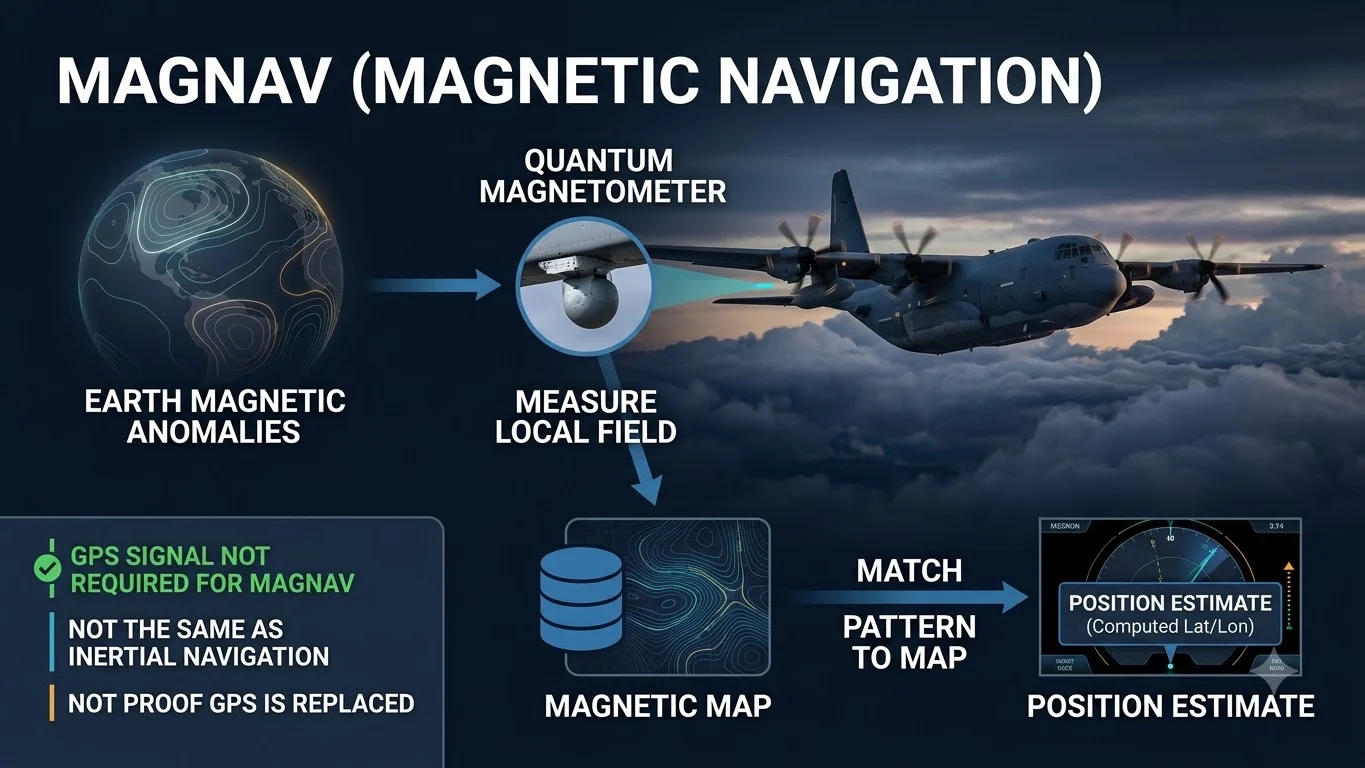
Quantum navigation without GPS does not mean an aircraft is navigating through quantum physics alone or has discarded every conventional navigation sensor. In the MagNav approach demonstrated by Honeywell and the US Defense Innovation Unit, highly sensitive quantum magnetometers measure small variations in Earth’s magnetic field and compare that measured pattern with a magnetic map to help estimate where the aircraft is.
The important idea is simple: Earth’s crust does not produce exactly the same magnetic signature everywhere. If an aircraft can measure that local magnetic pattern accurately enough and match it against a previously mapped reference, the pattern can provide another source of position information when satellite navigation is unavailable or deliberately denied.
A recent flight demonstration used an Embraer 170 and lasted about 4 hours 23 minutes. Reporting based on the Defense Innovation Unit demonstration says the aircraft flew from the Puget Sound area toward southern Alaska and back over the Pacific while GPS was unavailable or deliberately denied for the MagNav test. DIU reported an 89% improvement in positional accuracy compared with the conventional GPS-independent backup methods used for comparison.
What MagNav does: measures local magnetic-field variations and compares them with a magnetic map to provide an independent position reference.
What MagNav does not prove: that GPS is obsolete, that inertial navigation was absent from the test aircraft, or that magnetic navigation alone is ready to replace certified airline navigation systems.
Why the test matters: it provides evidence that magnetic anomaly navigation can contribute useful position information during a real aircraft flight when GPS is unavailable.
How does quantum navigation without GPS work?
MagNav is short for magnetic navigation. The version discussed in this demonstration uses very sensitive magnetometers whose sensing technology can exploit quantum effects to measure the strength of the surrounding magnetic field with high precision.
As the aircraft moves, the sensor records changes in the measured field. Those variations are influenced by magnetic properties in Earth’s crust. Software then compares the measured pattern with a reference magnetic-anomaly map.
If the measured pattern matches a distinctive part of the map, the navigation system can use that match to constrain its estimate of the aircraft’s location.
This is conceptually different from GPS. GPS determines position from signals transmitted by satellites. MagNav instead observes a naturally occurring geophysical field around the aircraft and compares it with a stored map.
Why is it called quantum navigation?
The phrase can be misleading because several very different navigation technologies are described as quantum navigation.
In this MagNav case, the important quantum component is the magnetometer: an extremely sensitive magnetic-field sensor that can use atomic or other quantum properties to measure the field precisely.
That does not make MagNav the same thing as quantum inertial navigation. Quantum inertial concepts generally aim to improve measurements of acceleration, rotation or motion using technologies such as atom interferometry. Magnetic anomaly navigation instead uses Earth’s magnetic-field pattern as an external reference.
Is MagNav the same as inertial navigation?
No.
An inertial navigation system estimates motion using measurements such as acceleration and rotation. Once initial position and velocity are known, an INS can continue calculating position without receiving an external radio signal.
The problem is that small sensor errors accumulate over time. This produces inertial drift.
Magnetic anomaly navigation provides a different measurement. By matching observed magnetic-field variations with a reference map, a MagNav system can provide position information that may help constrain or correct a navigation solution that would otherwise drift.
For that reason, TPS should not describe the Honeywell-DIU demonstration as proving the aircraft flew with no INS. The reviewed evidence establishes GPS-denied magnetic-navigation testing, not the complete absence of every inertial-navigation aid aboard the aircraft.
What happened in the Embraer 170 MagNav demonstration?
The demonstration used an Embraer 170 aircraft. Reporting on the Defense Innovation Unit programme says the flight lasted approximately four hours and 23 minutes and travelled from the Puget Sound area toward southern Alaska before returning over the Pacific.
During the MagNav demonstration, GPS was unavailable or deliberately denied so the team could evaluate the magnetic-navigation solution without depending on normal satellite positioning.
DIU reported that the system produced an 89% improvement in positional accuracy compared with the conventional GPS-independent backup methods used in the programme’s comparison.
The MagNav navigation information was also delivered to pilots on standard tablets rather than requiring the demonstration to replace the aircraft’s entire flight deck.
What does the 89% accuracy improvement mean?
The 89% figure needs a boundary.
It is a reported improvement relative to the GPS-independent backup methods used for comparison in this demonstration. It should not be translated into a claim that MagNav is 89% as accurate as GPS, that its absolute position error improved by 89% in every environment, or that all aircraft would reproduce the same result.
The exact operational performance of magnetic navigation can depend on the magnetometer, quality of the magnetic map, aircraft magnetic interference, altitude, geography, signal-processing methods and how the magnetic solution is combined with other navigation information.
Can planes already fly without GPS?
Yes, aircraft are not designed to become uncontrollable simply because one satellite-navigation source disappears.
Depending on the aircraft, mission and airspace, navigation can involve inertial systems, ground-based radio aids, air-data information, visual references and other approved sources. The important operational question is not whether an aircraft can remain airborne without GPS, but how accurately and safely it can continue navigating for the required mission and regulatory environment when satellite positioning is degraded or unavailable.
MagNav is being explored as another independent source that could strengthen this GPS-denied navigation stack.
Does MagNav use satellites?
The magnetic positioning mechanism itself does not require a live navigation signal from a satellite.
Instead, it uses onboard magnetic sensing and a reference magnetic map. That makes it attractive for environments in which GNSS signals are jammed, spoofed, obstructed or unavailable.
However, a complete aircraft navigation architecture can still contain other systems and data sources. Saying that MagNav itself is satellite-independent is different from claiming the entire aircraft used no satellite or inertial information of any kind during every phase of the flight.
Can GPS jamming affect MagNav?
Direct radio-frequency GPS jamming targets satellite-navigation signals. MagNav does not determine position from those same satellite signals, so ordinary GPS jamming does not attack the magnetic measurement through the same mechanism.
That does not make MagNav completely tamper-proof or universally immune to interference. Magnetometers can face aircraft-generated magnetic noise, environmental disturbances, mapping limitations and other sources of measurement error. A resilient navigation design therefore depends on sensor integration, integrity checking and redundancy rather than assuming any single technology is invulnerable.
Can quantum magnetic navigation replace GPS?
The flight demonstration does not prove that.
GPS provides highly accurate, globally available positioning and timing and is deeply integrated into modern aviation. A magnetic-navigation system would need to satisfy demanding requirements for accuracy, integrity, availability, reliability, mapping coverage, installation and certification before it could serve a defined civil-aviation role.
The stronger evidence-backed conclusion is that MagNav can provide an additional GPS-independent position source. That could make a navigation system more resilient when satellite positioning is denied, especially when magnetic navigation is integrated with inertial and other sensors.
Why magnetic maps matter
A magnetometer measurement alone does not tell the aircraft its latitude and longitude.
The measured magnetic pattern becomes useful for positioning when it can be compared with a sufficiently accurate reference map. Distinctive magnetic anomalies act somewhat like geographic fingerprints.
If two regions have very similar magnetic patterns, or if the reference map lacks the required resolution, position estimation becomes more difficult. Map quality is therefore part of the navigation system, not merely background data.
What could limit MagNav?
Magnetic map quality
The navigation solution depends on having useful reference data for the region being flown.
Aircraft magnetic noise
Electrical systems and metallic structures can affect sensitive magnetic measurements and require calibration or compensation.
Geographic distinctiveness
Some routes may contain stronger or more useful anomaly patterns than others.
Sensor and algorithm performance
Position accuracy depends on the quality of the magnetometer, filtering, map matching and integration with the broader navigation solution.
Certification requirements
A successful demonstration is not equivalent to approval for routine civil-airline navigation.
System integration
Operational value depends on how MagNav works with inertial, air-data and other navigation sources rather than on a single sensor in isolation.
Why the Pacific flight test matters
The strongest significance of the Embraer 170 test is not that GPS has been replaced. It is that a magnetic-navigation system produced useful navigation information during a long real-world aircraft demonstration in a GPS-denied test condition.
That moves MagNav beyond a laboratory-only concept and gives programme teams more evidence about how the technology behaves in an operationally relevant airborne environment.
The planned C-17 demonstration matters for the same reason. A successful test on another aircraft type could provide evidence about portability, integration and performance under different platform conditions.
What the demonstration does not establish
The reviewed evidence does not establish that MagNav is certified for routine commercial airline navigation. It does not establish that GPS has been replaced, that inertial navigation was absent, that the system is completely immune to interference, or that this was the first quantum-navigation aircraft flight in history.
Those distinctions are important because the term “quantum navigation” can make an experimental or developmental system sound more mature or more independent than the evidence supports.
Bottom line
Quantum navigation without GPS in the Honeywell-DIU MagNav demonstration means using highly sensitive magnetic measurements and a magnetic-anomaly map as an independent source of position information when GPS is unavailable.
It is better understood as another layer in resilient navigation than as a demonstrated one-for-one replacement for GPS or inertial navigation.
The Embraer 170 flight shows that the concept can operate during a substantial airborne demonstration. The next questions are how consistently it performs across aircraft and geography, how it integrates with other navigation sensors, and whether future testing eventually supports operational or civil certification.
Verification method
ThePulseSignal reviewed current reporting on the Honeywell and Defense Innovation Unit MagNav flight demonstration and technical literature describing magnetic anomaly navigation. TPS separated the demonstrated GPS-denied magnetic-navigation result from broader claims about inertial-navigation removal, GPS replacement, immunity to interference and civil certification.
Limitations and unresolved facts
The reviewed evidence does not establish that the Embraer 170 operated without an inertial navigation system, and it does not provide enough evidence to claim MagNav can replace GPS across normal aviation operations. Absolute position-error data, full test methodology, aircraft-specific integration details, certification plans and performance across different magnetic environments remain incomplete or unresolved in the reviewed material.